
Be sure to post any rarities on Mendobirds.
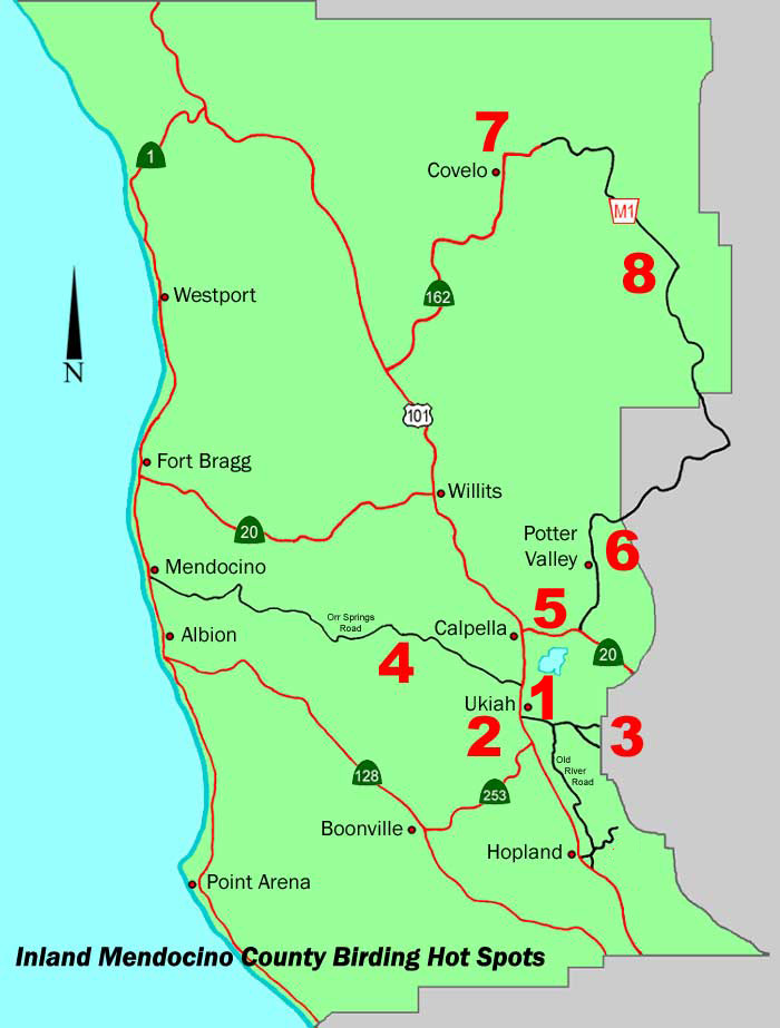
1. Riverside Park
This city property has easy access from Ukiah and Hwy 101, but is largely unimproved and does not have restrooms. It has multiple uses including 3 little-league fields and a BMX track. It was formerly a wastewater treatment plant and a dump of sorts, but it is slowly being renovated as the city finds grant funds to do so. At the north side of the property a recently-installed asphalt walkway leads east from the parking lot and intersects with a stairway down to the Russian River. The paved path continues to the south, eventually turns into a gravel path, and a bit further is a gradual ramp down to another vista along the river. Informal paths fan out to the south from here, some in better shape than others. The City will likely be cleaning up the southern portion of the property in the future, thanks to a recent grant.
Birding can be excellent, with 157 species currently having been recorded on eBird. Riparian, oak woodland and grassland species are well-represented, with occasional waterfowl. Year-round residents include all 5 of our local Woodpeckers, both Towhees, Bewick’s Wrens, Brown Creepers, Oak Titmouse, Bushtits, Black Phoebes, Finches and Goldfinches. Raptors including Kites, most of our Hawks and Falcons, as well as Belted Kingfishers, are also relatively common.
During the winter, birders could typically see both of the crowned Sparrows with an occasional White-throated Sparrow, Fox and Lincoln’s Sparrows, Ruby-crowned Kinglets, Yellow-rumped Warblers, Red-Breasted Sapsuckers, large numbers of Robins and Starlings, and occasional Ferruginous Hawks, Northern Harriers, and Say’s Phoebe.
Just about all of our lowland neotropical and other passerine migrants pass through and/or nest along the river during spring and summer, including Swallows, Cassin’s and Warbling Vireo, House Wren, Western Tanager, Hooded and Bullock’s Orioles, Black-headed Grosbeak, Western Wood-Peewee, Ash-throated and Pacific-slope Flycatchers, Western Kingbird, Rufous Hummingbird, Yellow,Black-throated Gray, and Orange-crowned Warblers, and Chipping Sparrows. Wood Ducks may nest here. Fall can be a great time to see southbound Willow Flycatchers along the river.
Directions: The park is located at the East end of Gobbi Street, which is a freeway exit within Ukiah. Make sure to park near the main gates, prior to the bollards near the BMX track area (which is typically locked but may be open temporarily during events). There are no restrooms.
2. Ukiah Waste Water Treatment Plant
At the Ukiah Waste Water Treatment Plant, or UWWTP, you can probably see more species of birds in less time than anywhere else in the Ukiah valley. Its habitat range is outstanding. UWWTP features settling ponds, beautiful stands of mature valley oaks, blackberry thickets, and mature pear orchards across the fence. All this along a wooded stretch of the Russian River. At times, one or more of the perc ponds will be emptied, providing nice mud flats and dried weedy areas. UWWTP is a great place to check for migrating warblers and shorebirds in spring and fall, ducks and grebes in winter, and breeding Black-headed Grosbeak and Common Yellowthroat in summer. County rarities seen here include Ross's Goose, Blue-winged Teal, American Bittern, Cattle Egret, White-faced Ibis, Swainson's Hawk, Sandhill Crane, Black-necked Stilt, American Avocet, Solitary Sandpiper, Semipalmated Sandpiper, Wilson's Phalarope, Black-headed Gull, Northern Shrike, Horned Lark, Tennessee Warbler, Palm Warbler, Blackpoll Warbler, Vesper Sparrow, and Swamp Sparrow. This is a good place to look for Peregrine Falcon.
Directions and Hours: UWWTP is located at 300 Plant Road. Take the Boonville exit off Highway 101 and turn right (north). The first street on your right is Plant Road: there's a flashing yellow light at the intersection. The plant is at the end of the road. The plant is open every day from 7AM to 3:30 PM. The gate is often locked, especially on weekends. Ring the bell to the left of the gate. If someone is in the office, they will let you in. If not, the phone number next to the button will connect you to a plant operator who will let you in. You can exit without assistance. YOU MUST CHECK IN AND OUT. The sign-in sheet is in the lobby of the main office on the right as you enter.
3. BLM Cow Mountain Recreation Area
The BLM Cow Mountain Recreation Area is seldom birded, but is the best area in the county to find some of our chaparral residents. Cow Mountain is divided into two areas: North Cow Mountain, where off-highway vehicles are prohibited, and South Cow Mountain where OHVs are permitted. Unfortunately, the birding is better in the south where the motorcycles are. Except for the small riparian area at Willow Creek and the mixed conifer/oak woodlands at the Mayacmas Campground, birding access in North Cow Mountain is largely through extensive areas of chaparral. While South Cow Mountain is criss-crossed with OHV trails, and vehicle noise can be annoying later in the morning, there is abundant habitat for birds in areas without roads. The Eightmile Valley area and the western edge of Lost Valley (accessed by foot from the Red Mountain Camp) are two of the best. In fact, any area with mixed conifer/hardwood, a habitat much less accessible in North Cow, has good birding. A dawn drive from spring through fall along the Mendo-Lake Road in South Cow is a great time to find Mountain Quail along the road edges. Bell's Sparrows, Wrentits, and California Thrashers are almost certain in the chaparral. Red-breasted Nuthatches and Hairy Woodpeckers are resident in the abundant patches of mixed woodlands. These are great areas to find nesting Nashville Warblers, and this is about the southern extent of their nesting in the Coast Range. It is possible that Olive-sided Flycatchers and Hermit Warblers, both of which have been observed here in the summer, also nest in the area. Rarities observed on South Cow include Greater Roadrunner, Black-chinned and Rufous-crowned Sparrows, and Lawrence's Goldfinches. "Thick-billed" Fox Sparrows winter here in fair numbers.
Directions: From Hwy 101, take Talmage Road east. Drive to the end, a little more than 2 miles, to the entrance to the City of 10,000 Buddhas. Turn right on Old River Road and drive south about 0.4 miles to the junction of Mill Creek Road on the left. There is a sign with access information on the right side of Old River Road here. Set your odometer here. Mill Creek Road is the only access road in Mendocino County into the Cow Mountain Recreation Area. Drive east and you climb through vineyards into Mill Creek canyon. In just over 2 miles you reach the larger of two visible reservoirs on your right. At the east edge of the reservoir is a paved parking lot. If you park here you can bird the reservoir area ("Mill Creek Pond"). This is also the trailhead for the Valley View trail on the north side of the road, or the Scorpion Trail accessed from the group picnic area just across Mill Creek to the southeast of the parking lot.
To reach Cow Mountain, continue driving east about 0.6 miles to an intersection. The road to the left is the access to North Cow Mountain. If you continue straight for 3 miles, winding further up Mill Creek canyon, you reach the staging area for South Cow Mountain. There is a parking lot here, with toilets and picnic tables. There is no potable water available in the Cow Mountain Recreation Area at this time. The road beyond this point is often closed in the winter due to muddy and impassible conditions
For access information and a free map to the area, contact the BLM Ukiah Field Office at 2550 North State Street (707-468-4000). A pdf map of South Cow Mountain is available here.
4. Montgomery Woods State Reserve
Montgomery Woods is not a particularly birdy area, but is worth a drive from the Ukiah valley in the evening during breeding season for owls. The road to the Woods winds through rolling oak woodlands and fenced rangeland. Barn, Western Screech-, Great Horned, Northern Pygmy-, Long-eared, and Northern Saw-whet Owls have been seen or heard here, as well as Sooty Grouse. The reserve has been home to both Spotted (historically) and Barred Owl (currently). Both have been found most frequently near the Kellieowen Grove. There is a lovely three mile loop trail through the park. A trail map is available at redwoodhikes.com.
Directions: Drive north to Orr Springs Road after exiting at North State Street in Ukiah from Highway 101. Turn west and drive thirteen miles to Montgomery Woods. The parking lot and trailhead are on the left.
5. Lake Mendocino
Lake Mendocino, the largest body of fresh water in Mendocino county, is owned and operated by the US Army Corps of Engineers. A few miles north of Ukiah, the lake is a popular boating, fishing, hiking, and camping destination. The birding can be excellent, especially in the off-season, when campgrounds are empty and wintering water birds move in. The USACE website for the lake can be found here.
Directions: Three entrances to the lake are currently open. The entrance to Bushay and Mesa campgrounds is closed due to debris remaining from last season's rainstorms.
Manzanita Trail
The southernmost entrance is via the Manzanita Trail. Exit Highway 101 at Perkins Street and drive east. Turn left at the end
of the road and continue for about two miles to Deerwood Drive. Turn right and continue to the end of the road, about five miles.
Park at the turnout. In the spring, this nicely wooded area is filled with the songs of Black-headed Grosbeak, Lazuli Bunting,
Western Wood-pewee, and Cassin's, Hutton's, and Warbling Vireos. Keep your eyes and ears open as you walk left across the bridge
and up a dirt road. Take the first left and proceed through the gate. Look for Bullock's Orioles, Western Kingbird, and
assorted woodpeckers. The trail continues down to the lake where it connects with the Kaweya trail.
The Ukiah Valley Trails Group's
website has more detailed descriptions of the lake's trail system.
Coyote Valley Dam
Take Highway 101 to the Lake Mendocino Drive exit. Head east to the stoplight on State Street, then turn left.
The next stoplight is Lake Mendocino Drive. Turn right and proceed to one of the parking lots near the end of the
road. Enter the first lot by turning left at the Overlook Day Use Area. There is a trailhead here for the three
mile Shakota Trail, which ends at the Pomo Day Use Area. This is the least birdy of the three options near the dam,
but ia nice hike with lots of elevation change.
The next parking lot is at the north end of Coyote Valley Dam. Lots of possibilities on a stroll across the dam. Rock Wren is often seen in the rip-rap at the south end and Bald Eagles are occasionally found on the island. Cliff Swallows nest under the gauging station structure and Osprey and Belted Kingfisher can be found keeping an eye on the steelhead collection facility to the east.
The woods on the northeast end of the dam have been roosts for huge flocks of wintering European Starlings and American Robins. Peregrine Falcons know this and at dusk the spectacle of thousands of the smaller birds landing and lifting as the raptors target a meal is breathtaking.
The last dam parking lot is at the South Boat Ramp, one of the best places inland for gulls. Eight species were tallied here on the 2010 Christmas Bird Count. With luck you might find a Thayer's, Mew, or Western Gull among the California and Ring-bills.
North Boat Ramp and Pomo Day Use Area
Exit Highway 101 at Calpella. Drive east across State Street to the end of the road and turn right.
The first left is Marina Drive. Turn here and continue to the Pomo Day Use Area or North Boat Ramp parking
lots. The woods along the lake can be productive and there is good scoping from the shoreline. Marina Drive
continues along the north edge of the lake until it joins Highway 20. It can also be accessed through the
Lake Mendocino Recreation Area - Marina Drive exit off Highway 20.
6. Potter Valley/Eel River
Potter Valley is a beautiful valley northeast of Ukiah, with riparian and habitat pastoral. As you continue north, East Side Potter Valley Road turns into the Eel River Road, which follows the Eel River east to Lake Pillsbury. George Chaniot has been a keen observer of Potter Valley birds here since 1971. Be sure to check his list before your visit. George leads a popular annual PAS field trip in mid-May. These directions describe the itinerary for that trip.
Directions: From Highway 101, take Highway 20 east toward Lake county. The Potter Valley/Lake Pillsbury/Road 240 turnoff is about five miles from the junction of 101 and 20 and exits to the north. You are now on East Side Potter Valley Road.
First stop is the old Potter Valley bridge, about 1/4 mile in on the left. The bridge crosses the east fork of the Russian River. American Dipper has nested here. Black-headed Grosbeak, Western Tanager, and Yellow-breasted Chat are often seen and heard in the spring. Another spot to check for dippers is near McKee County Park, another 3/4 mile up the road. Park in the lot, then walk north along the river. There is lots of poison oak here, but good views of the river as you proceed.
About 1/2 mile further north near milepost 1.37 is another parking area for McKee County Park with access to the river. Warbling Vireos, House Wrens, Yellow Warblers, and Black-headed Grosbeaks can be found among others.
Next stop is the pond at Burris Lane. Burris Lane is the first road to the right, about 3 1/2 miles in. Turn right and drive about 1 1/2 miles to a pullout overlooking a big farm pond on the right. George promises you'll see a Golden Eagle soaring overhead within 15 minutes. Burrowing Owls sometimes winter in the surrounding pasture, Lawrence's Goldfinches appear some years in to feed on the fiddleneck plants on the north side of the road, and Tricolored Blackbirds may be seen in the vineyards to the northeast. In winter Lewis's Woodpeckers are often conspicuous here.
Back on East Side PV Road, continue another mile and turn right on Pine Avenue. About a mile in is a beautiful spot with big oaks and a creek side pullout. George has found Mountain Bluebirds here a winter or two. At 1.1 mile is another pullout by the "Pine Avenue Association" sign. This is a good vantage point to see open country birds like Western Meadowlark, Western Kingbird, Say's Phoebe, Western Bluebird, or Prairie Falcon.
Just 3/4 mile further to the north, at 10700 East Side PV Road is a cattail filled pond, home to a springtime nesting colony of Tricolored Blackbirds.
Downtown Potter Valley is 6.6 miles off Highway 20. Turn right at the Lake Pillsbury/Eel River junction at Hopper's Corner. From this point proceed about 3.9 miles to a "Y". Bear to the right on "cutoff road" and continue 0.6 mile to the old logging road, currently signed "closed road", again on your right. The road is rough with big potholes so be careful. Stay to the left and park about 1/4 mile in. This is one of the most easily accessible places in the county for springtime Hermit and Macgillivray's Warblers. Walk the road, which parallels the south bank of the Eel River and keep your eyes and ears open for Western Tanager, Yellow-breasted Chat, Hairy Woodpecker, Hutton's, Cassin's, and Warbling Vireos as well. You never know when a Bald Eagle might fly by. Watch for Wood Ducks and Common Mergansers on the water.
Pioneer Bridge is just to the north. Drive over the bridge and turn left to the parking area. Purple Martins have been seen with the Cliff and Northern Rough-winged Swallows that nest under the bridge. Check the willows and oaks along the river for Wrentit, Lazuli Buntings, warblers, flycatchers, and Blue-gray Gnatcatcher.
PG&E operates the Trout Creek Campground a little over 2 miles east of the bridge off Eel River Road on the right. There is an active Osprey nest at about 1/2 mile. The campground is a lovely spot for a picnic, with benches, river access, and a mysterious fee schedule. Camping fees are posted, but day use fees are at the discretion of the campground host. You can also park off the road outside the campground and walk in. Dark-eyed Juncos, vireos, Black-headed Grosbeak are often seen and heard around the campsites. Yellow and Macgillivray's Warblers may be found in the willows at the river and Spotted Sandpiper on the gravel bars.
After lunch, head west on Eel River Road and turn right back at the Pioneer Bridge. Continue to the "Y" then turn right toward Van Arsdale Dam. Proceed about 3/4 mile then turn right on Van Arsdale Road. About 1/2 mile in you'll reach the Van Arsdale Fisheries Station parking lot. Park here then walk back up the road to overlook the dam and search for American Dipper. Look for Wood Ducks on the water above the dam and Common Goldeneyes in winter. Bald Eagles are possible year-round.
To get back to the highway, head back Van Arsdale Road. Stay to the right at the "Y" and you'll be back on the Eel River Road heading south to Potter Valley.
7. Covelo and Round Valley
Beautiful Round Valley in northeastern Mendocino county is famous for its variety of winter raptors. The Eel River canyon on the way to the valley hosts Bald and Golden Eagles, American Dippers, and is the most reliable area in the county for spring and summer White-throated Swifts. Peregrine Falcons (resident) and Lewis's Woodpecker (winter visitor) can usually be found, as well as many oak woodland specialties. The Mendocino National Forest can be entered from the north through Covelo.
Directions: Take Highway 101 north to Highway 162 east, about 36 miles north of Ukiah. Highway 162 winds through the Eel River canyon. Keep your eyes open for Golden Eagles. Park at the east end of the bridge at mile marker 15.13. Bald Eagle, American Dipper, and Canyon Wren can be found along the river and White throated Swifts nest under the bridge in spring and summer. If you are birding the area in the winter and have time, take a little detour to the Dos Rios bridge at mile marker 15.29. Turn north on the Laytonville-Dos Rios road and drive about one-half mile. Park at the south end of the bridge. Look over the bridge for schools of King Salmon and the occasional wintering duck.
After returning to Highway 162 continue to the turnout at mile marker 20.33 across from the sandstone cliffs. Peregrine Falcons nest in these cliffs and are often seen perched on or near them. In the spring, listen for breeding birds along the way. White-throated Swifts have also been seen here.
Continue to the town of Covelo if you need supplies, gasoline, or a restroom. There's one in the Redwood Market at the gas station. Park in the big parking lot at Keith's Family Food Center and scan the fields behind the market for blackbirds and sparrows.
From Covelo, you can visit two distinct habitats located in opposite directions. The first (Option 1) is to backtrack a bit and head for the valley fields to look for wintering raptors, sparrows, and Lewis's Woodpeckers, the second (Option 2) is to continue on Highway 162 up and out of Round Valley to the Eel River campground for oak woodland birds, Canyon Wren, and Golden Eagle. It's easy to cover both in one day-trip.
Option 1: Turn south (left) out of the market parking lot and drive about one tenth of a mile to the wastewater treatment plant entrance at 75991 Highway 162. Watch out for mud if it's been raining; park where you won't get stuck. Look for sparrows in the brush on the way to the settling pond and scan the pond for wintering ducks and geese. Back on Highway 162, continue south a couple of miles to Fairbanks Road and turn left. Drive slowly east, watching for Ferruginous Hawks on power poles and fence posts. Stop and check the oak trees for Lewis's Woodpeckers. Continue for about two miles to Dobie Lane at the end of the road and turn left. In the fall and winter, the fields for the next mile or two should be scanned carefully for Ferruginous and Rough-legged Hawks, Prairie Falcon, White-tailed Kite, Merlin, and Northern Harrier. In November of 2008, participants in a Peregrine Audubon Society field trip were treated to extraordinary views of a Short-eared Owl. Check the oaks along Dobie Lane for Golden-crowned Kinglet, Oak Titmouse, and White-breasted Nuthatch. Both Loggerhead and Northern Shrike have also been seen in this area. Always keep your eyes open for Lewis's Woodpeckers. The lane is often impassable at Mill Creek in the fall and winter, so plan on turning around after about a mile and a half, returning to Covelo for...
Option 2: Continue through Covelo on Highway 162 to the Black Butte/Eel River Campground, 12 miles east of town. Peregrine Audubon field trippers usually enjoy a picnic lunch here while listening for Hutton's Vireo and California Quail. The campground overlooks the river and it can be worthwhile to wander down to look for Canyon and Rock Wren as well as American Dipper.
8. Mendocino National Forest
UPDATE: The August Complex fire of August-October, 2020, burned over all of the area described below. While the fire was patchy, and few areas were totally consumed, the entire area was affected in some manner.
Mendocino National Forest (MNF) occupies the northeastern part of Mendocino County along its boundaries with Trinity, Tehama, Glenn, and Lake Counties. This is the only area in the county with expanses of high-elevation coniferous forests. These mixed forests support a number of montane bird species that occur there regularly during the breeding season, and are seldom found anywhere else in the county. A trip into this area in June (whenever the snow has melted) and early July should produce Flammulated Owl, White-headed Woodpecker, Hammond's and Dusky Flycatchers, Mountain Chickadee, Townsend's Solitaire, Green-tailed Towhee, and Cassin's Finch. Some rarities seen here include Northern Goshawk, Calliope Hummingbird, Clark's Nutcracker (fall), Mountain Bluebird, Black-chinned Sparrow, Gray-crowned Rosy-Finch (winter), Red Crossbill, and Evening Grosbeak (fall). The southern half of MNF is most convenient for travelers from Ukiah and these directions pertain to that area.
Directions: The access is through Covelo via Hwy 162, about 36 miles north of Ukiah off Hwy 101. Maps of the area are available during regular weekday working hours at the MNF offices on Hwy 162 just north of Covelo. Twelve miles east of Covelo are the Black Butte store and MNF Eel River Campground. Leave Hwy 162 and turn right here. Set your odometer at zero at the campground entrance. Crossing the bridge over the Black Butte fork of the Eel River, you begin your ascent into the mountains via MNF Road M1. This road is unpaved and passes through private property as it rises up Mexico Ridge. At 5.4 mi bear left onto Etsel Ridge. You cross a cattle guard at 6.4 mi and this is the MNF boundary. The lower parts of M1 pass mostly through oak savannah and the birds are all species you would more easily find around Ukiah. At about 12.8 mi, near the Post Camp junction, you begin to encounter good conifer stands. This is where you want to begin paying more attention. At 14 mi you reach Grizzly Flat (5800'), formerly a CDF summer fire camp. This is a good stopping point for lunch or a stretch and the large conifer grove above the road is a great spot to begin your montane birding.
Continue south on M1 and at 17.2 mi you reach Coffee Mill Flat. There is a fenced wetland to the right side of the road that can produce some nice birds. For the next 5 miles you pass through some dense conifer stands that provide interesting birding. At 22.4 mi, at the base of Bald Mountain, you reach the junction of M1 on your right, and M6 on your left. Continue right on M1. (Presently this road is only minimally maintained, but is passable for all vehicles with standard clearance.) In the next few miles M1 passes through several areas that have been logged in the last 10-15 years, and the standing snags provide great woodpecker habitat. One of these is at 24.5 mi, and White-headed Woodpeckers are often seen in this area. Continue on to 25.9 mi. This is at the bottom of a hill, with a wet meadow on the right (Millsap Cabin site). A narrow road on the left leads to Spruce Grove (6000'), probably the best single birding location we have found in MNF. The road is not maintained, but it is not too steep, and can be driven with care by 2-wheel drive vehicles with standard clearance. Staying to the left, drive in about 0.7 miles to a flat, open meadow and a very nice stand of old-growth Red Fir on the upper end. This is a great spot to camp (no water or toilets) and explore the extensive flat area around the grove. There is a wet meadow northeast of the camping area that also provides great birding. Spruce Grove is the best place in MNF to find Hammond's Flycatchers, and Flammulated Owls are seldom missed here.
Continuing south on M1 towards Hull Mountain there are other good birding spots. At 27.2 mi there is a small brush field above and left of the road- "Brushy Point". There is a wide turnout here and it is well worth the stop. Black-chinned Sparrows have been seen in the brush above the road, and Green-tailed Towhees are easily found below the road just to the south. At 28.9 mi you reach Monkey Rock on your right. From here to Hull Mountain, approximately 3 more miles, there are a number of small burns along the road from 2008 lightening fires. These are great places to look for woodpeckers. Driving south you will pass a treeless ridge, Windy Gap, which in June is covered with wildflowers and a great spot for hummingbirds. At the NW base of Hull Mountain there is a wide turnout on the right. Stop here if just for the views of Lake Pillsbury, Mount Sanhedrin, and the distant Ukiah Valley. In the early 2000's Black-chinned Sparrows were regular in the expansive brush fields to the south and west. A walk out the ridge to the west on the motorcycle trail to a large rock on Windy Point is worth the effort if you want to find these birds.
Continuing south on M1 to Lake Pillsbury is only for the intrepid or those with high-clearance vehicles. This road is not maintained, is very steep, and well rutted. The alternative is to backtrack the approximately 10 miles to the junction of M1 and M6. You can turn left and go back through Covelo, or proceed right on M6. This is the main road through southern MNF and is well maintained. There is good birding along M6 as you descend into Lake County to Lake Pillsbury. In 9 mi you reach a fork in the road. Continuing straight will lead you to Elk Creek or Stonyford and turning right will take you to Lake Pillsbury. If you continue to Lake Pillsbury and beyond, you will reach the junctions of M1 (to Upper Lake) and M8 (to Potter Valley) in about 22.5 mi. Either route will take you to Hwy 20 and a car wash.

Thanks to Chuck Vaughn, George Chaniot, and George Gibbs for their help preparing this page.
Last revised July 31, 2025.